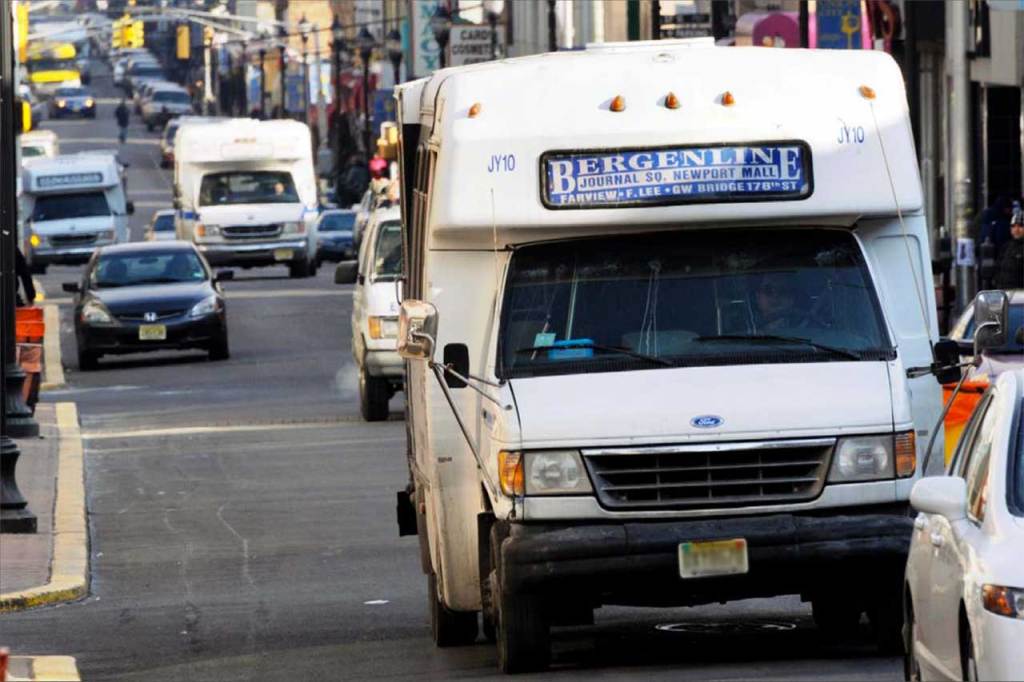
The north-south corridor between Jersey City and Fort Lee is probably the lowest-hanging fruit for heavy rail rapid transit service in America. It’s dense, urban, and heavily bus-dependent. New Jersey Transit and jitney buses carry a lot of riders along streets like Bergenline Avenue and Kennedy Boulevard, transporting people not only within urban New Jersey but to points in New York City as well.
Meanwhile, in the Bronx, there are several east-west corridors begging for higher-order transit. The busiest of these is along Fordham Rd and Pelham Pkwy, which is currently served by the Bx12 and Bx12 SBS buses which are among the busiest in all of New York City.
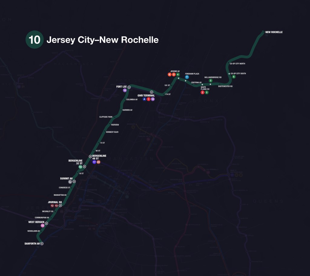
This is where Line 10 comes in. Line 10 would stretch about 27 miles from southern Jersey City to New Rochelle, with 32 stations. It would hit major destinations such as Journal Square, Union City, Washington Heights, Fordham Plaza, Co-op City, and more. The line would essentially be the backbone of the Greater New York Metro (GNYM) system, tying Hudson County, Bergen County, Upper Manhattan, the Bronx, and parts of Westchester County together into a single heavy rail rapid transit corridor.

As proposed, Line 10 unlocks some of the highest potential ridership in the region, including:
- North-south travel in Hudson and Bergen Counties
- Jersey City (Greenville, Journal Square, the Heights)
- The Bergenline, Anderson, and Palisade Avenue corridors
- Fort Lee and the George Washington Bridge crossing
- Washington Heights–Bronx travel
- Crosstown Bronx travel along Fordham Road and Pelham Parkway
The result: relief for some of the busiest bus routes in America, plus new and fast heavy rail transit connections between previously underserved neighborhoods.
I chose to begin these more in-depth posts with writing about Line 10 because of its enormous potential for ridership and its ability to become a catalyst for future growth. It encapsulates how heavy rail rapid transit lines should be planned—not as a band-aid for current problems, but as a forward-thinking solution for the future. Planning development in conjunction with efficient mass transit is how we can alleviate our housing crisis responsibly and cost-effectively.
Line Overview
Northbound Line 10 will begin at the Danforth Avenue station, located below the present-day Hudson-Bergen Light Rail (HBLR) station. A transfer will be available to Line 11—an important connection for Bayonne riders, who, with one transfer, would be able to reach Journal Square, Union City, Fort Lee, Washington Heights, the Bronx, and more. This particular station site has a lot of potential, not only for transit-oriented development (TOD) in the immediate area, but for a rail yard as well.
Traveling north from there, the tracks will run below Danforth Avenue before making a sweeping curve onto Kennedy Boulevard. To maintain a straighter alignment, the line will transition onto Bergen Avenue, where it will stop at Woodlawn Avenue station. Trains will then continue north along Bergen Avenue until it intersects the present-day HBLR West Side branch tracks. The HBLR’s current station is about 1,100 feet to the east at Martin Luther King Drive, so in my plan, I’m shifting this one west to Bergen Avenue and making it part of Line 15; Line 10’s station will be directly below it. I’m calling this station complex West Bergen.
The line will keep traveling north under Bergen Avenue, stopping at Communipaw Avenue station. Then it will diverge onto an off-street alignment to avoid several tight-ish curves that Bergen Avenue takes in the area. Trains will then stop at McGinley Square station, located just west of the intersection between Bergen Avenue and Montgomery Street.
The line will then continue off-street towards Journal Square station, curving eastward to intersect with the current PATH Journal Square station. As a massive hub for transit, retail, and new development, Journal Square acts as a second downtown for Jersey City. In my plan, the PATH will be converted into Lines 12 and 13 and this station would be a major transfer point for riders traveling between Line 10’s corridor and Newark, Downtown Jersey City, or New York City.
Line 10 will curve northward again to follow Central Avenue out of the Journal Square area. Along the mostly-residential Central Avenue, trains will stop at Manhattan Avenue and Congress Street stations. North of Congress Street, the line will curve onto Paterson Plank Road, joining the L train for a station at Summit Avenue (where the L terminates). This will be another major transfer point for riders traveling between points on Line 10 and places like Hoboken, Manhattan, or Brooklyn, and it represents a great opportunity for turning the surrounding neighborhood into a hub. After Summit Avenue, Line 10 will have a station at 18th Street before curving off-street and eastward to reach Bergenline Avenue and follow it northward.
Along Bergenline Avenue, the line will have stations at 32 Street (intersecting with Line 14 and providing a major transfer point for riders heading east towards Midtown or west towards Passaic and Paterson), 48 Street (intersecting with Lines 17 [Midtown and Queens] and 20 [Hoboken, Jersey City, Englewood]), 60 Street, 73 Street, and Kennedy Boulevard. According to my projections, this will be the busiest part of the line. Stations along this stretch will see about 37% greater ridership than the rest of the line, on average. This makes sense, as this part of Hudson County houses some of the most densely-populated municipalities in America and is just across the water from the the primary business district of the largest city in the country. After this section, the line crosses from Hudson County into Bergen County.
Entering Bergen County, Line 10 will mostly follow Anderson Avenue and Palisade Avenue. This stretch will serve the dense residential and mixed-use communities of eastern Bergen County, with stations at Fairview, Cliffside Park, Columbia Avenue, and Harmon Avenue. These stops will provide high-quality service to existing density (including several high-rise communities) while encouraging increased TOD in under-developed areas.
At the Fort Lee station, located just north of the downtown area, Line 10 will join with Line 16 for their shared alignment across the Hudson River on the George Washington Bridge. This will also be a transfer point, connecting riders to destinations along Line 16, like Passaic, Hackensack, the South Bronx, Soundview, Flushing, Jamaica, and JFK Airport. This connection should accelerate Fort Lee’s transformation into a regional hub, sparking even more development.
Crossing the Hudson River, the line will continue to a major station complex below the George Washington Bridge Bus Terminal. Here, riders will be able to transfer again to Line 16 as well as the A train, linking directly to Inwood, Harlem, the Upper West Side, Midtown, Lower Manhattan, Brooklyn, and Queens. The 1 train is also a few blocks away, but a direct transfer connection may not be feasible due to the distance, geography, and development of the neighborhood.
Leaving Manhattan and entering the Bronx, Line 10 will turn northeast to follow University Avenue through the Bronx, with stations at 174 Street and 181 Street serving surrounding densely populated residential neighborhoods. The route will then curve east to meet Jerome Avenue, where the line will connect with the 4, B, and D trains. Roughly following Fordham Road, the line will stop at Fordham Plaza, one of the Bronx’s largest commercial hubs that directly abuts Fordham University. Here, transfers will be available to the planned T train and Metro-North commuter rail.
East of Fordham, Line 10 will follow Fordham Road and Pelham Parkway with stations at Crotona Avenue, White Plains Road, Williamsbridge Road, and Eastchester Road, offering transfers to the 2 and 5 trains and serving key areas in the eastern Bronx. Trains will then curve northward toward Co-op City, where there will be stations along Baychester Avenue at Bartow Avenue (Co-op City South) and Co-op City Boulevard (Co-op City North). Together, these stations will anchor one of the city’s largest housing communities and the Bay Plaza shopping area.
Finally, Line 10 will follow the New York Thruway to cross from the Bronx into Westchester County, where New Rochelle station will mark the end of Line 10. This intermodal station will allow transfers to Metro-North commuter rail, Amtrak, and Bee-Line buses.
Ridership and Travel Time Projections
Ridership projections were generated using a custom model I developed in Python. The model draws on US Census, MTA and NYC data to measure how certain factors affect ridership on existing NYC Subway station locations and predict ridership for other locations, such as future station sites.
Based on these calculations for Line 10, ridership is projected to be strong (averaging 3.187 million yearly riders at each station), with especially high numbers in Hudson County and at major transfer hubs such as Journal Square, Summit Avenue, 48 Street, GWB Terminal, and Fordham Plaza.
Travel times were calculated using a collaborative infrastructure planning tool called Podaris. Travel times between important nodes are as follows:
- Danforth Avenue to Journal Square: 6 minutes
- Journal Square to 48 Street: 9 minutes
- 48 Street to GWB Terminal: 14 minutes
- GWB Terminal to Fordham Plaza: 6 minutes
- Fordham Plaza to Co-op City South: 7 minutes
| Station | Annual Riders | Travel Time |
|---|---|---|
| Danforth Avenue | 3.720 million | 0:00 |
| Woodlawn Avenue | 1.255 million | 0:02 |
| West Bergen | 2.134 million | 0:03 |
| Communipaw Avenue | 1.671 million | 0:04 |
| McGinley Square | 1.766 million | 0:05 |
| Journal Square | 8.349 million | 0:06 |
| Manhattan Avenue | 1.714 million | 0:08 |
| Congress Street | 2.041 million | 0:09 |
| Summit Avenue | 10.767 million | 0:11 |
| 18 Street | 2.203 million | 0:12 |
| 32 Street | 4.241 million | 0:14 |
| 48 Street | 10.059 million | 0:15 |
| 60 Street | 3.007 million | 0:16 |
| 73 Street | 2.253 million | 0:18 |
| Kennedy Boulevard | 2.335 million | 0:19 |
| Fairview | 1.991 million | 0:21 |
| Cliffside Park | 1.961 million | 0:22 |
| Columbia Avenue | 1.639 million | 0:23 |
| Harmon Avenue | 1.399 million | 0:25 |
| Fort Lee | 2.779 million | 0:27 |
| GWB Terminal | 7.655 million | 0:29 |
| 174 Street | 1.564 million | 0:31 |
| 181 Street | 1.773 million | 0:32 |
| Jerome Avenue | 6.251 million | 0:34 |
| Fordham Plaza | 7.730 million | 0:35 |
| Crotona Avenue | 1.402 million | 0:36 |
| White Plains Road | 2.103 million | 0:38 |
| Williamsbridge Road | 2.598 million | 0:39 |
| Eastchester Road | 1.147 million | 0:40 |
| Co-op City South | 2.627 million | 0:42 |
| Co-op City North | 0.814 million | 0:44 |
| New Rochelle | 2.984 million | 0:48 |
Conclusion
Line 10 will give the areas it serves the frequent and fast rail service they deserve, better connect them to the region at large, and spur development in an increasingly stagnant and expensive region. Its importance to the region and its transit network cannot be understated, and for that reason, it’s imperative that it gets built in some form or another.

Leave a comment